Tuesday, 25 July 2017

Season 13 - Gibraltar to The Canary Islands


Hi All:


It has been a while since we have posted to our blog, the last time being when we did our partial Pacific crossing.

But we are now back aboard Two Moons , enjoying our 13th season and true to form, unexpected events have occurred which delayed our departure from the winter berth in Almerimar, Spain by more than a month. Things, which worked perfectly when we lifted the boat in the fall of 2015, inexplicably required repair or replacement. In cases for which a spare was not aboard, 80% of the job was chasing down a replacement.
 
The pic shows how not to overload your boat, if you don’t want to attract attention. This 42 foot boat was escorted into the Almerimar marina by the Spanish Coast Guard, because they only had about 6-8” of freeboard showing, before the decks were awash. At the dock they unloaded 11 tonnes of marijuana and hash. The captain claimed he didn’t know it was there.

All this was inside the white boat .
 
From Almerimar, we sailed directly to our last Mediterranean port of call - La Linea de la Conception, with further hopes of acquiring spares to complete the repairs. It was not to be. We stayed in this Spanish port for another two weeks scouring all the automotive, chandler and repair shops for parts, until we finally gave up and decided to make do and bring the parts back the illusive parts in our suitcase next spring.
 

La Linea is right next door to Gibraltar, which involved only a 20 minuet walk to The Rock, which we did practically every day. Although we had already visited the top of the rock when we entered the Med in 2010, the return experience couldn’t be missed. The Barbery Apes continue to stand guard and the vistas are just as satisfying. We didn’t repeat the tunnel walk inside the Rock, which is about 200 yards long, but subsequently, learned that there are 26 miles of tunnels inside.

 In the mid left is the Gib airport runway. North is where we are moored in Spain. South is all Gib.

 
Although Gibraltar is right at the gap leading into the Med, timing is everything when leaving. If you don’t get it right with wind and tide, the sea can be more than unpleasant. Added to that, the constant stream of container ships passing through the mouth of the Med is one of the busiest channels in the world. So we planned and we waited until the wind and tide and stars were all perfectly aligned. At the two hour mark we were quite chuffed with ourselves. We got it right. Then the fog closed in. There was not fog in the forecast. At one point in the trip we needed to cross the shipping lanes. Ship fog horns where blaring from everywhere, but you couldn’t see them. Without the use of AIS, GPS and radar, it is not a trip we would ever contemplate.

 
There were two places we had tentatively wanted to visit on our exit. First Tangiers, which has a brand new billion dollar marina, with which they hope to attract tourism. It would have been a nice stopover, but were denied entry because the Moroccan king hasn’t officially opened it yet. So it sits unused until the royal visit. The second place was Madeira. We took a pass on stopping here because of our previous experience with Portuguese officialdom. We are at the end of our allowable time in the Schengen Territory and didn’t wish to give them opportunity to fine us for overstaying our welcome again.

 
So we sailed directly to The Canary Islands, which was a six day passage of rock and roll. We have prepared for this down wind sailing, when crossing to the Caribbean, with something called a Twistle rig configuration, but it seems best bent on when in port, not underway.

 
We stayed well off the African coast (50 miles) not wishing to make ourselves available to any uninvited guests. Twice, fishing boats appeared from ocean side and seemed to come closer than need be, only to turn and continue shoreward. In both cases nerves were on edge until they were out of sight.

 
Our landfall was La Graciosa, the most NE island of the Canary archipelago. We anchored in a beautiful sandy bay, out of the wind, surrounded by the volcanic hills of La Graciosa and Lanzarote. It was a superb place to recharge despite the arrival of the afternoon tour boats.


Apparently each of the islands have their own personality and La Graciosa is not yet on the tourist flight plan. The topography is all volcanic with no vegetation. All roads are packed sand, so Land rovers are the vehicle of choice. PIC
 

We moved south on to the next island – Lanzarote- because of a high wind forecast. The Trades have definitely settled in with a constant breeze of NE 10-20 knots. It is much like La Gaciosa, with volcanic hills and planes. Not much vegetation, but an interesting attempt at growing grapes. Each vine lives in its own pit out of the impact of the wind. The end result is a rather sweet, expensive red. Sorry, couldn't get a picture of that.


Lanzarote is also trying to minimize the impact of the growing tourist industry, which is beleaguering its cousin islands. The white-washed block house, with their mandatory blue, green or brown painted woodwork have an eye pleasing uniformity.


We have three more islands to visit before holding up for winter, which is where we will pick up on our next posting.

 
Good summer to all……….Mike and Grace


Monday, 19 September 2016

Plan B (Aug 30'16) - New Zealand/Tasmania/Australia


Plan B    (June 22- Aug 30’16)

 
Following our sudden change of plans from sailing across The Pacific (the boat was sold in Tahiti), we opted to continue on to Austral-Asia and go land-yachting. In short, we traveled from Tahiti to New Zealand, Tasmania and ending the trip in Australia. 

All told we drove 15,000 kilometres in three “cramper” vans over a period of three months and absolutely loved it. This is despite the fact we were travelling in their winter period, when the sun didn’t rise until “eightish” and set by five at the latest, was very chilly (especially in New Zealand), and mostly had beaches and camp sites to ourselves.


far too many beaches like this
 

New Zealand:

South Island: From the Auckland airport, we went directly to the van rental depot and quickly experienced our first surprise. We had booked a van on-line based upon the recommendation of some seasoned Kiwis, who must still be laughing at the joke they pulled on two dumb Canucks. The van was very basic, but it was the graphics that elicited the double take. Sweat bands and cheap sun glasses were provided, but we had to buy our own weed. This was like our vanning days back in the early 70’s. Needless to say, we never had any trouble finding our chariot in a supermarket parking lot.


We covered the southern island in a clockwise direction and every turn in the road seemed to produce a “wow”! But apart from the heavy morning frost (which didn’t dissipate until noon where there was tree canopy, the lack of any straight road was the only misgiving (that and it was all left hand oriented) and dictated constant vigilance of the white line.

 
Everywhere, the landscape proved fascinating, but it was the Fox and Joseph Franz glaciers that topped our list. To be able to walk on the glacier beds, which only 30 years ago, were ice encased, was spectacular. Our guess is that the glacier retreat will be complete in 10 years time.

Fox Glacier
Franz Joseph Glacier
Fox Glacier bed


Maeraki Beach meter sized marbles


Milford Sound
enroute to Milford Sound


Milford Sound


North Island: The ferry crossing to Wellington on the north island could not have been smoother.

 As before, we tried to cover the island in a clockwise direction, but frequently found because of mountain ranges – “you can’t get there from here”.  The active geo-thermal area of Rotarua was a destination not to be missed and was punctuated by the Maori villages in the area. They still utilize the boiling waters for heating, bathing and cooking. You only have to get used to the rotten eggs smell.

Geothermal Valley
Maori Village

Maori Village
Unique to the island are the monster sized Kauri trees. These giants have a trunk circumference of over 15 meters and are over 2000 years old. Fallen trunks that have been submerged in rain forest mud for 1500+ years are highly sought for furniture, because it is impervious to rot.

 
Kauri Tree
 
The landscape is a gorgeous blend of mountains and pasture land and while still very appealing, our vote went to the southern island as having the most eye candy.

The Kiwis have definitely made travelling around their country easy with abundant tourist information, rest stops, excellent signage and a welcoming attitude. The four weeks and 5,500 kilometres flew by effortlessly. We’d love the chance to revisit and walk some of the many alpine tracks which weren’t open to us at this time of year.
 

Tasmania

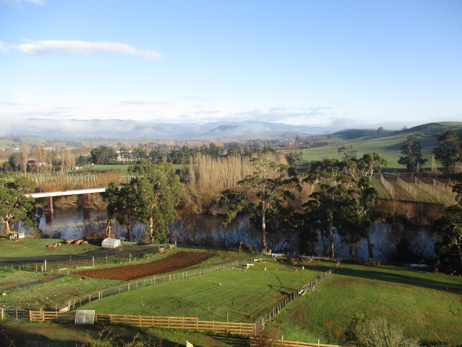
Being smaller in size, we opted to stay only one week and weather conditions being what they were, this was simply a touring holiday. Heavy rains closed many roads, which was taken as a common occurrence by the locals. Such wash out areas are all marked by a permanent depth indicator, so you can determine if you your vehicle can make the crossing. But generally the roads are good and distances between points short.

Over 21% of Tassies’s land is dedicated to National park and much only accessible by foot or four wheel drive. Although Tasmania is part of Australia, it is like Australia and it is not.

A good day to be ON a land-yacht

pastoral Tass - hops and grapes

Hobart


Hobart
Australia:

Like Canada, Australia is a big place and distances are large scale. We started out in Melbourne, Victoria, followed the coast NW up to Adelaide, South Australia. From there we turned NE towards Brisbane, New South Wales. Then headed south to Canberra and finally to Sydney. Without a doubt, it is our opinion that Australia has far more of their share of beautiful coastline and beaches than any where we have visited.


When we crossed the interior from Adelaide to Brisbane, skirting the Outback, we had anticipated vast dusty orange vistas, but found all to be green owing to the past two years of substantial rain fall. Only once did we attempt driving on an unsealed road and quickly found ourselves up to the axels in sticky red mud. Only our experience from driving in snow, saved us from a hefty tow job.


typical Outback with a little Mad Max
 
typical outback gear with reinforced roo bumper


go anywhere outback camper

Just west of Canberra, in the Blue Mountains, we visited the Jenolian Caves, of which there are many such sites around Australia. These particular limestone caves are 10 kilometres long and the depth has yet to be determined. They are also the oldest such caves in the world and contain limestone formations which boggle the mind. The few pics here hardly do justice to the depth of colour, size and complexity of the formations.


We could babble on for pages about the sites in the SW corner and have definitely put a return visit back onto the bucket list. Only the next visit will be to see the WNW coastline.

Home:

We are now back home in Canada, enjoying the warm fall weather and summer harvest and thinking where did the time go? We enjoyed ourselves so much, even in the cramper vans, we wonder - is there a………… land-yacht in our future? 


Before we think any more about that, we need to rescue Two Moons from the dusty boat yard in Spain and prepare her for a return trip to the west side of the Atlantic in 2018.

Best wishes to all…..G’day……….Mike and Grace  (mobile 226-600-5051)


camp site vermin
 
cockatoos - make crows sound like song birds

 
Mt Cook

half of NZ


12 Apostles  - Aus Great Coast Rd.


Saturday, 18 June 2016


Marquesas-Tuamotus-Tahiti - Plan B  July ‘16


Marquesas – Nuku Hiva


Before we left the Marquesas, we rented a car to tour Nuku Hiva. The vistas we encountered were marvellous. The extreme ranges in flora as the elevation changed made you question if you were still on the same island. PICS The road itself was a challenge going from 5 kilometres of paved two lane to single lane goat track and back to paved for no explicable reason. We rarely got out of 2nd gear! Chickens are everywhere, but in the higher elevations cows and horses roam freely (mainly on the road). Wild pigs were also a common site.


With such lush vegetation, we couldn’t understand why we needed to be at the local vegetable market by 5:00 am in order to get the slim pickings that were offered. The real treat, however, was at the local dock where fresh yellow fin tuna was to be had for $5 a kilo.
Early on the docks for fabulous tuna
A great tiki rebuild (except the palm leaf roof is plastic)


This is one island that definitely held “the wow factor” for us.


The Tuamotus


After a week at Nuku Hiva, we moved on. Having just been “fixed” after two hours the auto pilot packed it in again, which necessitated 200 more miles of hand steering.


The Tuamotus are a series of coral atolls covering an area 600kn by 1500km and are said to be the largest group of coral atolls in the world. Only half have a pass enabling a boat to enter inside the reef which must be negotiated with the tides and depending upon what the winds have been doing there could be a build-up of water inside or a deficit changing the nature of the water flow.


Look close for one that didn't get the tides right

According to Darwin these circular reefs are the remnants of a volcanic island, where the coral reefs formed around the shores. But the volcano has since disappeared leaving the low string of palm fringed islands making up the atoll.

We had no problem with our first atoll Ahe, but once inside found it littered with bouys marking the black pearl oyster beds.

Our first atoll was Ahe,  a smaller one where you can see all inner shores (motus) once inside. Some of the motus are connected by low concrete bridges built by French legionaries. The principal mode of transport around Ahe, apart from the open fishing boats was the three wheeled bicycle. Some cars and trucks, but when your stretch of road is only 5-10 kilometers the bike makes good sense. Folks were very friendly and quickly realized our high school French was something best forgotten.
The dark blue patch is 500 meters/the white is 2 meters

The string of motus ringing the atoll
Homes are smallish, run on solar panels, have large water catchment systems, with many having additional reinforcement against the winds.
This is the rope and sand bag approach

Practically everything comes in by boat from Tahiti – food, building supplies, fuel and this is reflected in the price.

Snorkelling around the many coral heads was not inspiring because the coral is struggling owing to bleaching from the sun. Fish population is diminished due to coral decline and overfishing by the locals.


Our second atoll was Rangiroa. One with a very large interior, such that you couldn’t see the other side and it had two passes. The water in the passes runs quite strong, but apparently it is wide enough and deep enough to enable a large cruise ship to slip in.

Across the atoll is a lagoon (Blue Lagoon) which could be visited by your own boat, but because of distance, the many coral heads and poor anchoring possibilities we opted for a day trip with a local tour operator. The ride over and back at 20+ knots in lumpy seas will remain memorable. But, although the lagoon was very picturesque the snorkelling was lacklustre. Inside the lagoon were many black tipped sharks (benign) ranging in length up to about one meter and constantly hovering around while swimming. Outside the lagoon, where the tour operator threw all the lunch leftovers were lemon sharks 2-3 meters long, creating quite a frenzy when the food hit the water.

 A BBQ on the beach was provided and at the end of the meal three large parrot fish were laid on the BBQ. Instinct said – don’t eat the parrot fish/they are coral fish and susceptible to ciguatera (a toxic substance that comes from the coral and works its way up the food chain). But the belly said – it looks good and the locals are eating it. Should have listened to the brain. I had an afternoon of what we dubbed Rangiroa Rage, but Magnus’ endured his for three days. – if in fact that’s what hit us.

 On the return trip the operator dropped us into the nearby pass and here the snorkelling was exceptional. Vibrant coloured coral and fish were to be found in abundance. Unfortunately it was an out going tide and we were swept past much quicker that we would have liked. So we later visited another pass by dinghy and found the same plethora of sea life, which we enjoyed at our own pace.

Before we left the Rangiroa atoll we visited a local pearl farm to learn how the oysters are seeded to create the pearl and why they are black. The pricing however remains a mystery.

Inserting the shell irritant into an oyster


Note the white shell irritant in the center


Tahiti


We were fortunate in leaving for Tahiti when we did because the weather changed and blew hard the following week. Safely inside the reef which rings Tahiti we watched the 2-3 meter waves crash upon the reef, curling along in one continuous wave for hundreds of meters. At the right sun angle the entire wave shone an azure blue. Just the stuff brochures proclaim.

Doesn't do it justice - a 3-4 meter wave breaking over the reef


Plan B

We are now moored in the Tanai Marina, Tahiti, having sailed 4600 nautical miles and have been notified by the owners that they are selling the boat here in Tahiti. The long distances and constant mechanical break downs have been more that they wished to endure.


So Grace and I have booked flights to New Zealand, Tasmania and Australia and will be renting “land yachts” (camper vans) to complete the passage we had originally envisaged. Sounds like a good plan, but it is now their winter period and this morning’s check on weather indicated night time temperatures in the range of two and three degrees Celsius. Snow might also be possible in the more southerly areas. At least the beaches won’t be crowded, but there goes the tan.


We have done some touring around Tahiti and agree it is our least favourite destination this summer. There aren’t the high rise hotels you see in Hawaiian travel pics, but there are 117 kilometres of road with 40,000+ vehicles. I’ve stood where Captain Cook stood in 1769 to take his sextant sights on Venus and also where Captain Bligh landed in 1788. The vegetation is very lush, PIC  but we just haven’t encountered “the wow factor” experienced in other landfalls. The people remain very friendly, but it is just too busy, noisy and uninspiring. You have to admire the tattoo artwork displayed on practically everybody and it is tempting……… but on a 66 year old sagging body, I fear an embarrassing smudge may be the best result. I feel like we are going to miss the best part of the Pacific Islands by ending the sailing trip here, but maybe another opportunity will arise where we can make those missed landfalls and then we can reconsider that tattoo.


Nana (goodbye)……….Grace and Mike


The land crab (this one about 25cm) lives in a burrow, climbs trees and can cut through a coconut husk and shell